Logistica全国貨物自動車電子キロ程
by はるかシステム研究所
Features Logistica全国貨物自動車電子キロ程
【Overview】"National freight car business kilometer map" is a business kilometer map of automobile routes created based on the notification of own currency No.
66 on July 5, 1972.Even today, many shipper companies and logistics sites in the transportation industry still use this paper-based operating kilometer map.Logistica National Freight Car Electronic Kilometer will record the "National Freight Car Business Kilometer Map" on your Android device.
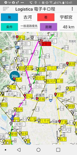
It is an android application that calculates the search route and distance of the "national freight vehicle business kilometer map" by tapping the departure / arrival point.Instead of manually searching for the departure / arrival route / distance using the paper-based "national freight vehicle business kilometer map", the departure / arrival marker is used on the android smartphones digital "national freight vehicle business kilometer map".
Tap to automatically calculate the distance and route.
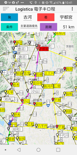
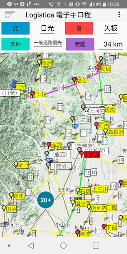
The digital version of the "National Freight Car Business Kilometer Map" is the "Logisica Electronic Kilometer Map".Logisita is a registered trademark of Haruka System Research Institute Co., Ltd.[1] Logisica Map of electronic kilometers① Map operationWe will post the "National Freight Car Business Kilometer Map" on Google Maps.The map operation of the electronic kilometer map is the same as the basic operation of the base Google map.・ Scroll with one finger to move the map.・ Double tap with one finger to enlarge the map of the place.・ Tap with two fingers to reduce (zoom out) the map.・ Pinch in / pinch out (open / close) with two fingers to enlarge / reduce the map.② Map typeSelect from "Normal map", "Topographic map", "Satellite image", and "Hybrid" of Google Maps.③ RoadThe following is a list of road types (road display colors) to be recorded.・ Main national road (green)・ General national highway (yellow)・ Local road (gray)The main national road is a route connecting major cities.④ PointThe following is a list of point types (pin color, background color of point names) to be recorded.・ Prefectural government city (red pin, red)・ City (red pin, yellow)・ Town (yellow pin, yellow)・ Village (white pin, white)・ Intersection (gray pin, white with city name in parentheses)⑤ Section distanceBusiness kilometers by point section are displayed in white background near the center of the section road⑥ OtherHonshu and Hokkaido are connected between Aomori and Hakodate.[2] Functions of Logisica electronic kilometers⑦ Distance calculation conditionsSpecify either "General road priority" or "Main road priority".There are two types of roads: general roads and major roads."General road priority" searches for the shortest route regardless of the road type."Main road priority" gives priority to the green main road and searches the route.The distance between Tokyo and Osaka is 576km for "main road priority" and 555km for "general road priority".⑧ Departure / landing pointTap the point marker to specify the starting point and landing point.The starting point is the blue push pin, and the landing point is the red push pin.⑨ Search routeThe search route connecting the roads is color-coded in pink.[3] Supported OSAndroid OS 4.4 or higher
Social Features
Connect and share with friends and the community.
Gaming Features
Enjoy immersive gaming experience with various game modes.
Learning Tools
Enhance your learning experience with interactive features.
See the Logistica全国貨物自動車電子キロ程 in Action
Get the App Today
Available for Android 8.0 and above